Table of Contents
- 1 Coconino Sand Dunes:
- 2 Navajo Sand Dunes:
- 3 Tapeats Sandstone:
- 4 Similar Features in the Coconino Sandstone?
- 4.1 Fossilized sand dunes are steep like those found in modern desert dunes:
- 4.2 Sand grains are well-rounded like those of desert sand dunes:
- 4.3 Sand grains are well-sorted as with desert sand dunes:
- 4.4 Sand grains are frosted, indicating a desert environment:
- 4.5 Fossil raindrops prove a subaerial eolian environment:
- 4.6 Vertebrate footprints support a desert environment rather than an underwater environment:
- 4.7 Recumbent parabolic folds:
- 5 Conclusion:
Coconino Sand Dunes:
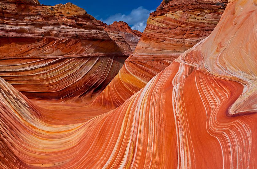
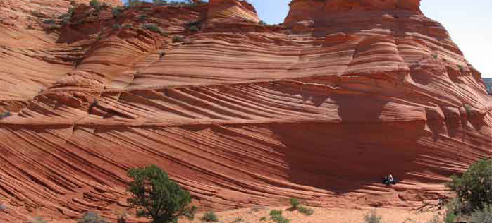
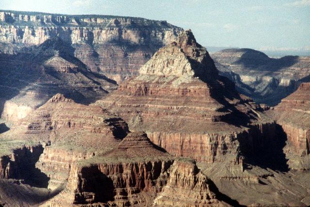 For many, one of the strongest evidences against a worldwide Noachian-style Flood is the presence of large deserts preserved within the fossil record. One of the most striking and common examples cited is the Coconino Sandstone – one of the more noticeable layers within the Grand Canyon. Third down from the rim of the Grand Canyon, it is tan to white in color and up to 1000 feet thick at its southern edge (Mogollon Rim in Arizona) and thins to a few feet in thickness along its northern limits (boarder of Utah). It is a crossbedded deposit, with individual horizontal units composed of 30 or 40 layers of fine sand sloping at 20º-30º that are occasionally up to 75 feet long (McKee 1933).
 According to most modern geologists, these layers were laid down between 280 to 260 million years ago during dry desert conditions similar to modern deserts like the Sahara Desert in northern Africa. The popularity of the desert origin for the Coconino Sandstone began with the work of McKee in the early 1930s (McKee, E.D., 1933). McKee initially focused on the physical qualities of the sandstone to support his conclusions that the dunes had been wind and not water deposited. Later he studied the footprints that are found within the Coconino Sandstone and concluded that they were most likely formed on dry sand (McKee, E.D., Tracks that go uphill. Plateau, 1944, 16(4):61-73).
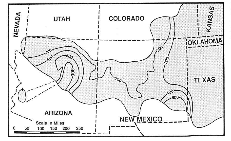
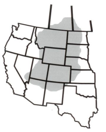
Extent of Coconino Sandstone
So, from a biblical perspective, how in the world could such a desert exist right in the middle of sediments that are supposed to have been laid down by a worldwide Noachian Flood? It just doesn’t seem to make any sense given the truth of the biblical perspective. While it is true that most of the Paleozoic sedimentary layers within the Grand Canyon are clearly marine sediments, such as the Kaibab and Redwall limestone layers, how can the desert layers of the Coconino Sandstone be explained by a Noachian-style Flood?
Consider the problem from the perspective of Steve Newton (programs and policy director for the National Center for Science Education, a nonprofit devoted to defending the teaching of evolution in public schools – www.ncse.com) who wrote about this problem in 2011 as follows (Link):
In support of their case, creationists point to the fact that most of the Paleozoic rocks in the Grand Canyon are marine sediments, such as the Kaibab and Redwall limestones. Creationists point to these rocks and rightly say that water was involved, as limestone forms in the ocean. But the creationist Flood model suffers from one terrible, gaping, fatal flaw that threatens everything: the Coconino Sandstone.
The Coconino is an eolian deposit, meaning it records dunes flowing across a dry desert landscape. It is very clearly an eolian deposit, displaying classic wind-blown features such as frosted sand grains and large crossbedding formed from dunes rather than currents. The Coconino is sandwiched between rocks supposedly formed during the year of the Flood, and yet it could only have formed on dry land.
The Coconino sands stick in the eye of the creationist model.
_______
[Note: See also an interesting paper by Timothy K. Helble along these lines: Link]
It seems quite clear then that the creationist worldwide Flood model, promoted by the Seventh-day Adventist Church in particular, simply doesn’t hold water. After all, how in the world can the existence of these desert sand dunes be explained in the middle of a Flood that is supposed to have only lasted about one year?
Under water formation:
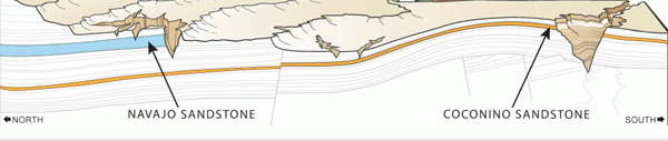
 Well, consider the story of the Navajo Sandstone as an illustration of how perceptions can change as new information comes to light. The Jurassic Navajo Sandstone (several layers above the Coconino Sandstone as illustrated above) is also a crossbedded sandstone, similar in many respects to the Coconino Sandstone. And, it just so happens that the Navajo Sandstone was also originally interpreted by geologists to be a preserved desert (an “eolian” or desert layer within the fossil record). However, by the early 1970s some geologists had begun to reevaluate this position, suggesting instead that the Navajo Sandstone was best interpreted as marine sand waves (Dott and Batten 1971; Marzolf 1969; Stanley et al. 1971). Consider the following comments about this change in interpretation:
Extent of Navajo Sandstone
Since 1903, most of the Navajo sands were assumed to represent ancient wind dunes formed on a vast Sahara-like desert; this became a ruling hypothesis…. The Navajo problem originated years ago when geologists could conceive of large amplitude cross stratification as originating only in wind-formed dunes; no other modern processes that could form it had been studied. This highlights the major short-coming of reasoning by analogy, namely the limitation at a given time of known possible analogues. Today, knowledge of modern shallow marine sedimentation has broadened the spectrum of counterparts of analogues. Insight gained into remarkably large underwater dunes found on very shallow shelf areas provides as attractive a comparison for much of the Navajo sands as for lower Paleozoic quartz sandstones (Dott and Batten 1971, p. 359).
Inasmuch as geologists are forced to interpret ancient sediments chiefly by analogies with modern phenomena, interpretations are severely biased if all possible modern analogues are not known; such was the case when the Navajo was first studied (Stanley at al. 1971).
 Sedimentary features that were formerly thought to be diagnostic of eolian deposits are now known to be non-diagnostic. Stanley et al. (1971) pointed out that “grain frosting is no longer considered a criterion of wind transport,” grain size distribution statistics have been ambiguous (for the Navajo), and “it can no longer be assumed a priori that large festoon cross strata prove an eolian dune origin for the Navajo or any similar sandstone because of the essential identity of form and scale of modern submarine dunes or sand waves, as documented during the past decade” (e.g., see d’Anglejan 1971; Harvey 1966; Jordan 1962; and Terwindt 1971).
In 1975 this conclusion was affirmed by Freeman and Visher (Journal of Sedimentary Petrology, 45:3:651-668; Link) who also pointed out that:
The Navajo Sandstone (Upper Triassic-Lower Jurassic) has been interpreted as desert-eolian in origin principally based upon “eolian type” cross-bedding; well-rounded, well-sorted, and frosted grains; and lack of fossil evidence. Reevaluation of these criteria reveals that they are ambiguous, non-diagnostic, and insufficient to substantiate an eolian interpretation. It was found that comparisons of log-probability curve shapes of samples from Navajo and modern tidal-current environments show they were deposited by similar processes. The Navajo possesses sedimentary structures, such as current lineation, bioturbation, and large-scale contorted bedding characteristic of subaqueous conditions of deposition. Pelletal glauconite occurs in a correlate of the Navajo, the Nugget Formation of the Wind River basin, indicative of a marine environment…
Underwater sand dunes are known to accumulate on portions of the sea floor swept by strong currents–for example, beneath the North Sea. Superficially they look a lot like desert (windblown) sand dunes, but careful analysis of their grain size distribution reveals major differences. It turns out that disaggregated sands from the Navajo Sandstone match very well with modern submarine dunes, and very poorly with desert dunes. If the Navajo Sandstone formed underwater, as the data seem to indicate, then one must imagine water depths on the order of 300 feet and current velocities of 4 feet per second across large portions of North America!
[Leonard Brand also cited this evidence for the under-water formation of the Navajo Sandstone; Link].
 Of particular note here are features cited by Freeman and Visher that are, even today, found only in marine dunes. This includes Pelletal glauconite and current or parting lineation in particular. Current lineation is a subtle sedimentary structure in which sand grains are aligned in parallel lines or grooves on the surface of a body of sand (or lithified as a sandstone).
Some have argued that these same types of current lineations have been produced by wind on dry desert sand – such  as in the eolian dune deposits in the Libyan desert (Brookes, 2001 – Link). However,
these erosional lineations (illustrated to the left) don’t look anything like current
lineations created by flowing water (illustrated above and right).
Other features that suggest underwater formation for the Navajo Sandstone include large folds in the sandstone. Such folds “indicate that thicknesses in excess of several hundred feet were in a water-wet and unconsolidated state at the same time. This too suggests rapid underwater burial.” (Link)
Of course, these arguments were met with some resistance with some arguing in response, “I do not doubt that parts of the Navajo are indeed marine, but to say that some of it is marine and therefore all of it is marine is not logical stratigraphy.” (Link)
Coming full circle (desert formation):
Ralph Hunter:
Of course, since the 1970s there has been much debate about the depositional environment of the Navajo Sandstone. It seems that, since around 1977 (following a paper by Ralph Hunter which systematically described stratification types within eolian dune sands, 1977), things have come full circle so that most modern geologists again believe that the Navajo Sandstone was in fact deposited as desert dunes after all – not as underwater sandwaves (Link). This conclusion is further supported by the production of various stratification types within wind tunnel experiments (Fryberger and Schenk, 1981). Unfortunately, no “water tunnel” or other underwater laboratory experiments or even field investigations were done with large sand waves in order to better understand the potential similarities and differences between the two processes.
Angle of repose:
In any case, one of the most commonly cited features of the Navajo Sandstone that seems to favor a desert dune origin is the high “angle of repose” of the dunes of about 24˚ on average (compared to the angle of desert sand dunes of about 32˚-34˚) – though some have argued for a steeper angle of 28˚ for the Navajo Sandstone. In any case, this reduced angle is “significantly lower than the angle of repose on comparable modern dunes” (Link). The difference in angle is usually explained by the subsequent “compression” or “compaction” of 24-29% by the weight of the overlying sediments (Link, Link, Link). However, this assumption is not supported by actual experimental evidence with the compaction of sand under laboratory conditions as far as I’ve been able to tell. And, there appears to be no microscopic evidence of this degree of necessary compaction (Link).
Also, consider that the morphology of the material affects the angle of repose; smooth, rounded sand grains cannot be piled as steeply as can rough, interlocking sands. Also, consider that the angle of repose for underwater sand can range from 10–30° (Link). While it is true that underwater sand dunes generally “avalanche” occur more easily compared to desert dunes, reducing the average angle of repose for underwater dunes (the angle of repose for underwater sand dunes is typically <20˚), the range of the angle of repose for underwater dunes is still quite significant, occasionally reaching >30˚ with greater angles associated with larger sand waves (Link). In other words, the pitch increase as the energies, wavelengths and heights increase. For example, the sand waves in the Strait of Juan de Fuca average 20˚. Other sandstone cross beds are greater than 34˚ ruling out subaerial deposition of dry sand altogether and showing that subaqueous deposition can also be greater than 34˚ – which sort of undermines this particular criterion as something definitively diagnostic of desert/eolian vs. underwater origin.
Carbonate lenses:
Some have also argued that the “carbonate lenses” founding within the layers of the Navajo Sandstone are clearly “evaporates” and therefore cannot be explained by underwater formation:
Carbonate is an evaporite. It forms when water rich in dissolved carbonate evaporates. How could there have been multiple dry periods of sufficient duration or intensity to form the carbonate lenses scattered throughout the 2000 feet of Navjo Sandstone if the sandstone itself was formed in the middle of a global flood? (One creationist insisted to me that carbonate is not necessarily an evaporite. It was a precipitate. And evaporation is just one mechanism for precipitating carbonate from solution. That is technically true and irrelevant. I am unaware of any model, however implausible, for “precipitating” the carbonate lenses in the Navajo Sandstone. The carbonate lenses look like evaporation deposits.)
Beyond the fact that the Navajo Sandstone has very common lenses and beds of limestone and siltstone (clearly the result of water deposition), consider that the very term “evaporite” suggests the presence of a fair amount of carbonate-saturated water to be “evaporated”. Consider also that in the context of a massive worldwide Noachian-style Flood the waters all over the planet would be heavily saturated with carbonate material to begin with. Any kind of temporary ebbing of the water from a particular location, allowing for periods of calm and settling of sediments would most certainly allow for the local precipitation of carbonates as well – and the formation of carbonate lenses (along with the common lenses and beds of limestone and siltstone). This would certainly have been the case for the Navajo Sandstone region which shows evidence of periods of exposure of the sand in between the waves the Flood.
Wind-Ripple Laminae:
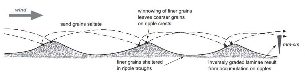
 Given that finding a solid criterion or set of criteria for distinguishing eolian sand dunes from underwater sand waves seems to be rather difficult to come across, upon what basis can modern geologists find confidence when interpreting a particular formation as eolian? Well, according to Kocurek (1991), the most solid way to make such a determination is based on the presence of “wind-ripple laminae.”
Without question, wind-ripple laminae are the most distinctly eolian stratification type. No identical structure exists in subaqueous cross strata. Differences do exist between subaqueous and eolian grainflow deposits and, perhaps counter to intuition, grainfall is rarely preserved in subaqueous cross strata, which are dominated by grainflow deposits.
Kocurek, G., Interpretation of Ancient Eolian Sand Dunes, Annual Review of Earth and Planetary Sciences, 1991, Vol. 19, p.52 (Link, Link)
So, what are these all-important wind-ripple laminae that produce “pinstripe laminations” in fossil sandstones?
“Wind-ripple forms are sometimes preserved, such as where they are buried by grainfall deposits, but wind-ripple laminae are more common. Each lamina is the product of a single wind ripple. The laminae are thin (a few millimeters thick), closely packed and distinct. The laminae are commonly inversely graded, reflecting grain segregation on the wind ripples, in which the coarser grains are near the upper part of the lee slope.”
Reading, H.G., Sedimentary Environments: Processes, Facies and Stratigraphy, 2009, Ed. 3, p. 131
This is an interesting argument. However, very similarly graded pinstripe laminations are in fact found within underwater sediments – especially “heterolithic” sediments (heterolithic bedding is a sedimentary structure made up of interbedded deposits of sand and mud). “Heterolithic facies are typically laminated and contain pinstripe laminations, starved ripples, and well-developed tidal cycles (cyclical tidal rhythmites)” (Archer, 1994 – Link)
Also, for “wave-formed ripples” the internal structure of ripples is a base of fine sand with coarse grains deposited on top since the size distribution of sand grains correlates to the size of the ripples. This occurs because the fine grains continue to move while the coarse grains accumulate and provide a protective barrier (Link). As far as I can tell, this is very similar to the wind-blown sand ripples where the grading is also course to fine.
Beyond this, ripples within the Navajo Sandstone are rare, occurring only in a few localities in widely scattered parts of the formation. This is interesting because permanent preservation of such delicate ripple marks requires at least some degree of sand cohesion – which in turn would require wet or at least damp sand at minimum (McKee, 1945, p. 324). Later, McKee himself, in 1979, pointed out that large submarine sand waves had been discovered that showed many external features of desert dunes. However, the internal structure of these large marine sand waves had not been studied (McKee, 1979, p. 217) – and still have yet to be studied as far as I’m aware. In light of this evidence, McKee’s main reason for continuing to favor a desert environment for the formation of the Navajo Sandstone rested primarily on the presences of animal trackways and dinosaur remains which, in his words, “precludes the possibility of those parts having formed under marine conditions” (see discussion below – Link, Link). The numerous lenses and thin beds of limestone and siltstone found throughout the Navajo Sandstone (clearly requiring deposition by water), are interpreted by McKee and others as “interdune deposits”.
Beyond this, it is possible, even during a world-wide Noachian-style Flood, to have temporary regressions of water from a particular region following tsunamis or large-scale tidal actions. This would allow for the occasional exposure of land, which would in turn allow for the preservation of such things like raindrops, trackways, and even dinosaur nests.
Original questions unanswered:
Beyond this, many of the key arguments presented by Freeman and Visher against an eolian environment remain unanswered – to include the poorly sorted nature of the Navajo Sandstone:
There is considerable contrast between Navajo curves and Holocene desert-eolian curves. Specifically, in eolian curves, a steep, well-sorted, dominant saltation population develops with the bed-load and suspension populations much less pronounced or entirely absent … ; Navajo grain size curves have less well-sorted saltation populations and although in some cases lacking a coarse poorly-sorted bed-load population, the majority has suspension populations marked by a 3.24-3.75 phi break … There appears to be no systematic location of intrapopulation or interpopulation breaks in eolian curves.
Freeman W. E., Visher, G. S., 1975. Stratigraphic analysis of the Navajo Sandstone. Journal of Sedimentary Petrology 45(3):651-668.
Also, as discussed below for the Coconino Sandstone, there are several other features of the Navajo Sandstone that are much more consistent with deposition by water than by desert dunes…
Cross country transport:
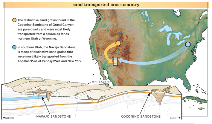
Subsequently, it has been argued that the sand itself was transported across the entire continent from the Appalachians of Pennsylvania (based on grains of zircon crystals that contain uranium similar in character to those of the Appalachians). If this is true, the sand grains were transported at least 1,800 miles (3000 km) right across North America. And, the evidence is overwhelming that the water was flowing in one general direction to carry this much sediment across the entire continent. More than half a million measurements have been collected from 15,615 North American localities, recording water current direction indicators throughout the geologic record. The evidence indicates that water moved sediments across the entire continent, from the east and northeast to the west and southwest throughout the Paleozoic. This general pattern continued on up into the Mesozoic, when the Navajo Sandstone was deposited. How could water be flowing across the North American continent consistently for hundreds of millions of years in some complex river system for which no evidence exists? These findings seem to be much more consistent with very rapid transport of massive sheets of water from a Noachian-style Flood.
As Arthur Chadwick points out:
“During the Paleozoic, in sharp contrast to Mesozoic, Cenozoic and Precambrian tendencies, clear and persistent continent-wide trends are normative. Sediments moved generally from east and northeast to west and southwest across the North American Continent. This trend persists throughout the Paleozoic and includes all sediment types and depositional environments. A gradual shift is seen from lower and mid Paleozoic westerly trends to upper Paleozoic southerly trends… Paleozoic paleocurrents indicate the influence of directional forces on a grand scale over an extended period. Various authors have attributed the directionality to such things as “regional slopes,” but it is difficult to see how this could apply to deposits of such diverse origins over so wide an area. The lack of strong directionality in the underlying Precambrian sustains the need to seek understanding of what makes the Paleozoic style of sedimentation unique with respect to directional indicators.” (Link).
Conifer trees:
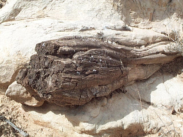
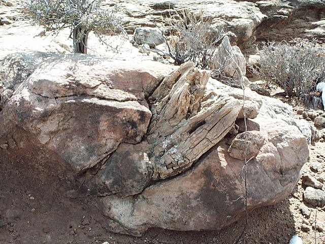
What is also quite remarkable, from the perspective of a Sahara-like environment, is the “widespread occurrence” of conifer trees, pine trees of all things, preserved within the Navajo Sandstone. “Tree trunks are occasionally associated with massive sandstone beds interpreted as fluidized mass flow deposits.” It is argued that these situations occurred “when dune slip-faces collapsed during occasional heavy downpours of rain, destroying stands of trees. The occurrence of large conifers over a wide area of the Navajo Sandstone Formation in south-east Utah may record long-lived pluvial episodes… The underlying sandstone is visible at some carbonate mounds and is massive or contains aeolian stratification, but is typically carbonate-cemented.” (Parrish, 2007 – Link). The trunks of the trees are stripped of branches and bark, which are not associated with these trees, and the stumps only have small attached knotted root fragments with shallow to non-existent root systems (Parrish, 2007 – Link).
 All of these features are very similar to what were once thought to be a series of forest that grew one on top of the other over thousands of years, ending up as “stacked forests” at Specimen Ridge in Yellowstone. Around 1900, F. H. Knowlton proposed the theory that the petrified trees on Specimen Ridge were forests petrified in place over tens of thousands of years. His theory remained dominant through most of the 20th century as recorded on information signs for visitors to Specimen Ridge (Link).
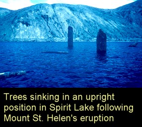
However, it is now known that these “forests” weren’t really forests at all. The trees were actually transported by mud and water with many buried in the vertical orientation – which initially lead to them being interpreted as being “in the position of growth.” Of course, all of these features actually favor a catastrophic model of deposition and burial (Link). And, the Navajo Sandstone trees also show many similar features as do the Specimen Ridge trees – to predictably include a “preferred orientation in long-axis direction of the trunks. In one bed, trunks are aligned in a dominantly NNE–SSW orientation, whereas in a second bed at another locality, trunks exhibit a dominantly NW–SE orientation” (Parrish, 2007 – Link). This same type of orientation can also be seen at Specimen Ridge.
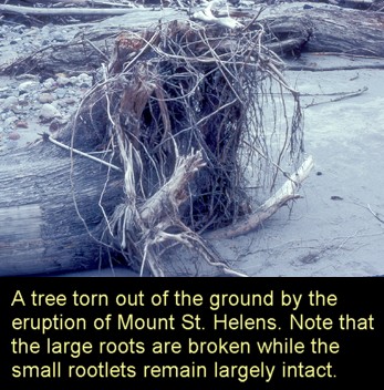 Also, how are conifer trees, in large numbers over long periods of time, going to survive in the shifting hot desert sand dunes? Certain no such equivalent conifer trees are known to exist in such inhospitable desert conditions… not even close. “Modern examples of oases… are dominated by palms” (Parrish, 2007 – Link). The very existence of these fossilized trees, then, within the Navajo Sandstone, is a complete mystery for modern mainstream scientists who believe that this must have been a desert environment rather than a massive catastrophic flood deposit (Link). Also, the consistent orientation of these trees with respect to each other is hard to explain without invoking deposition within water with current orientation – as with the Specimen Ridge trees. The vertically oriented trees that are supposedly “in the growth position” in both the Navajo Sandstone and the Specimen Ridge location are also oriented with respect to flow and numerous other features suggest that they sank in water in this position and were then buried in the vertical orientation. The reasons for this include a general lack of well-developed root systems, the loss of branches and bark without any evidence of these materials associated with the remaining tree trunks and stumps, and minimal bioturbation or evidence of animal life of any kind associated with these trees or the closely surrounding environments.
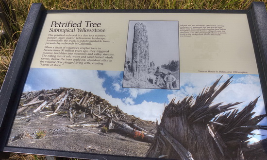
Sign at Specimen Ridge (2015) citing the catastrophic origin of layers of petrified trees – with no mention of the previous promotion of “stacked forests” which had been promoted for so long…
It is unfortunate that many Christians have lost their faith in biblical credibility the biblical perspective on origins over such issues. For example, Ronald Numbers, a popular historian of science, claimed to have lost his faith in the credibility of the Bible when he learned of the “stacked forests” of Specimen Ridge:
I vividly remember the evening I attended an illustrated lecture on the famous sequence of fossil forests in Yellowstone National Park and then stayed up most of the night … agonizing over, then accepting, the disturbing likelihood that the earth was at least thirty thousand years old. Having thus decided to follow science rather than Scripture on the subject of origins, I quickly, though not painlessly, slid down the proverbial slippery slope toward unbelief.
Numbers, R., The Creationists: The Evolution of Scientific Creationism, University of California Press, 1992. p. xvi
Of course, the Scriptures turned out to the right and the notion of tens of thousands of years of sequential forests at Specimen Ridge turned out to be wrong. Yet, even though the story of the “stacked forests” of Specimen Ridge has since been recognized, even by mainstream scientists at the National Park Service, as a mistaken interpretation of the evidence in favor of a more rapid catastrophic model like the one creationists have been advocating for many decades (Link), it is almost always too late for those like Ron Numbers and many others who have lost their faith in the Bible to recover it again…
Dinosaur Skeletons:
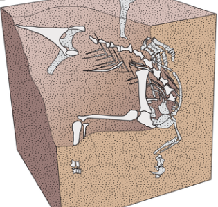
 It is also interesting to note that the skeleton of a small dinosaur was found in the Navajo Sandstone in northern Arizona that was oriented with the axis of the body parallel to the dipping planes of crossbedding (Camp, 1936. p. 41). This situation seems much more consistent with water orientation of a body rather than wind orientation. Also, the right hind foot was pressed into the sand, which suggested to Camp that the dinosaur was possibly still alive when it was buried by the sand.
 Of course, many of the other skeletal remains are incomplete, suggesting burial after death – but still with some orientation with respect to the dune itself, and sometimes buried by dune “slumps.” Slumped and massive sandstone beds are locally common in the lower 10 meters of the Navajo Sandstone and likely represent collapsed dune faces. The preservation of one of the skeletal remains (“UMNH VP 18040“) is located within sandstone that is identical to laterally equivalent sandstones, but lacks foreset cross-bedding. The sand bed that preserves these remains is
As far back as 1979 McKee argued that these types of sand folds or slumps, sometimes recumbent, in the Navajo Sandstone would require that the sand be wet (McKee, 1979 – Link). A 2001 article published in the journal Nature argued that the degree of wetness needed to produce such slumps would require “heavy rain” events referred to as annual “monsoons” (Loope et al., Annual monsoon rains recorded by Jurassic dunes, Nature 412, 64-66 – 5 July 2001).
Clastic Pipes and Dikes:
 There are also interesting structures known as clastic pipes or dikes within the Navajo Sandstone and numerous other sandstone layers in this region and around the world. A clastic dike is formed when a layer of liquefied sediment squirts up into an overlying layer or layers of sediment (see diagram). This only happens in modern flooding and mudslides if the lower mud layer or sandy layer was still soft and recently deposited just before additional layers were added on top of it. The extreme pressure of sedimentary layering on top of a soft layer causes the soft layer to “squirt up” at intervals through the layers above it.
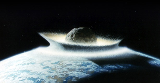
Most geologists currently interpret these clastic dikes as having formed during earthquakes associated with asteroid impact sites where the sediments were liquefied by these events (Link). Now, one might think that after a few million years that all the layers would be turned into solid rock. How then could solid rock “squirt” up into overlying layers of rock? Some have argued that certain types of sediment, such as the sand which forms sandstone, does not necessarily have to solidify and become cemented just because it has been buried under high pressure for long periods of time. The general argument is that overlying shale layers consolidate before much water can escape from the underlying sandy layers. In this way the consolidated shale acts as a seal to prevent water from leaving the sandy layers (which seems kind of strange for a Sahara-like desert by itself). So, the overlying pressure does not compact the sand in order to aid in cementation. The overlying layers simply “float” on a layer of highly pressurized water. When some sort of disturbance happens to crack the overlying layers of sediment, like an earthquake, the liquefied sand squirts up with great force through this crack and forms a clastic dike or pipe.
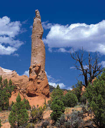
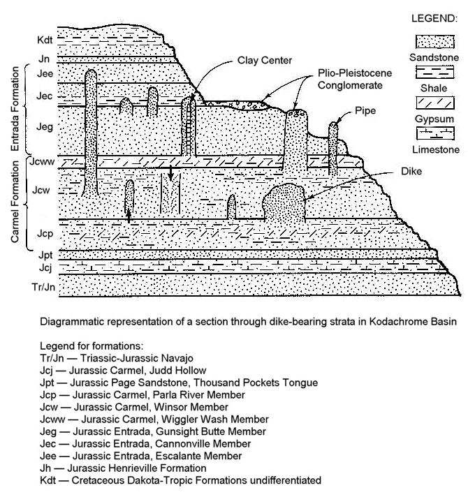 The problem with this argument is that liquefied layers are simply not that common today – certainly not after “millions of years”. It just doesn’t happen. Consider that during modern earthquakes in the region, sandstone layers do not liquefy and produce similar clastic dykes. Only unconsolidated sand layers are able to produce this effect – not sandstone that has already been cemented into stone. In this light, it seems rather strange then that so many ancient sandstone layers, supposedly separated by millions of years of time all around the world, would remain so unconsolidated and prone to liquefaction. Some of these clastic dikes even have central cores of clay. How can a layer of shale that is supposed to be preventing liquid water from leaving the underlying sandstone layers itself remain subject to liquefaction over millions of years of time? What is so special about these porous areas that layer after layer of sediment avoids cementation over millions of years and retains the ability to squirt up like soft toothpaste into overlying layers? – to include those layers made out of silt as well as sand? An overburden of more than 1200 m (4000′) of sediment once covered the now-exposed area where many of these pipes are found (like the Kodachrome basin). These numerous layers would have created a pressure of 275×105 Pascals (4000 lb/in2). Such pressure would induce rapid cementation, precluding a Plio-Pleistocene intrusion (Link) – especially in porous sandstone layers.
It seems that a much easier explanation would be that all of the layers were in fact formed rapidly and catastrophically, one on top of the other, while all of them they were all still soft and unconsolidated (not yet cemented). The pressure of the overlying wet sediments caused many of the underlying soft layers to squirt up all over the place through various weak points in the overlying soft sediments – especially during seismic activity.
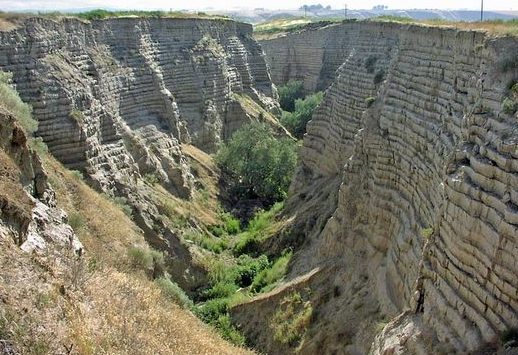 In fact, there are modern examples of this. To illustrate, consider the Scablands of Washington State. Before Harlan Bretz came along, the sedimentary layers and other features of these Scablands were thought to have formed over millions of years. However, Bretz argued for many decades that all of these features were formed catastrophically by a single huge flood. Despite the strength of the evidence in his favor, his arguments were largely ignored for many decades. Only after the source of the flood waters was found at Missoula Lake did his arguments finally carry day and become generally accepted (Link).
After a while, however, the single-flood hypothesis began to be challenged in favor of multiple huge floods occurring over hundreds of years (Waitt, 1985, 1987). A few subsequent papers challenged the multiple flood hypotheses in favor of Bretz’s single-flood concept. In particular, Shaw (1999) argued that the available evidence suggested that all of the dozens of layers of sediment or “rhythmites”, especially highlighted at Burlingame Canyon, are best explained “as resulting from multiple pulses, or surges, within a single flood.” (Shaw, 1999). One of the cited reasons for this conclusion is the presence of clastic dikes within these layers. These clastic dikes cut through numerous beds and sometimes through the whole sequence of layers. This indicates that the dikes were formed under pressure temporarily in excess of lithostatic pressure within the layers themselves, and that most of the clastic dikes formed after the deposition of the entire sequence had been completed. Otherwise each bed would have its own set of dikes, generally separated from other rhythmites. Shaw et al. postulate that the rapid draining of the lake, while the groundwater head at depth in the sediments remained high, caused explosive release of water that formed the clastic dikes.
The dikes imply the following conditions: (1) porewater pressures at their point of origin must have been temporarily in excess of lithostatic pressures to allow eruption (Allen, 1982); (2) those crosscutting the entire succession must have formed after deposition of the entire sequence; and (3) pore-water pressures increase with depth. Sudden lake drainage of dammed waters would have decreased pressure at the lake bed, while the groundwater head at depth in the sediment remained high. An explosive situation ensued and pressure was released as water escaped mainly by lateral flow in sand and gravel toward dikes that carried water and sediment to the surface. Arguments for multiple floods, with long interludes of subaerial exposure, are contradicted by the sedimentary evidence at this site.
Shaw, J., Munro-Stasiuk, M., Sawyer, B., Beaney, C., Lesemann, J.-E., Musacchio, A., Rains, B. and Young, R.R., The Channeled Scabland: back to Bretz? Geology 27(7):605–608, 1999. (Link)
Of course, since this time the single-flood theory proposed by Shaw has been challenged by several others (Whitman, 2011). Such evidences include features such as rodent burrows and erosion channels that were originally cited by Waitt – which may be explained by short-term exposure during a series of closely-spaced flooding events – given the lack of significant bioturbation or vegetation. Even given the validity of multiple closely-spaced floods, there was clearly not enough time for cementation or solidification of the sedimentary layers, allowing for the formation of numerous clastic dikes in this region – explaining why Shaw’s clastic dike arguments appear to remain unchallenged even if his single-flood hypothesis has a few significant difficulties. And, as illustrated above, these very same features are also present for the clastic dikes that are found within the Navajo Sandstone as well as other sandstone formations within the geologic column around the world – arguing for the relatively rapid formation of most of the layers within the geologic column – to include the various sandstone layers like the Navajo and Coconino Sandstone layers.
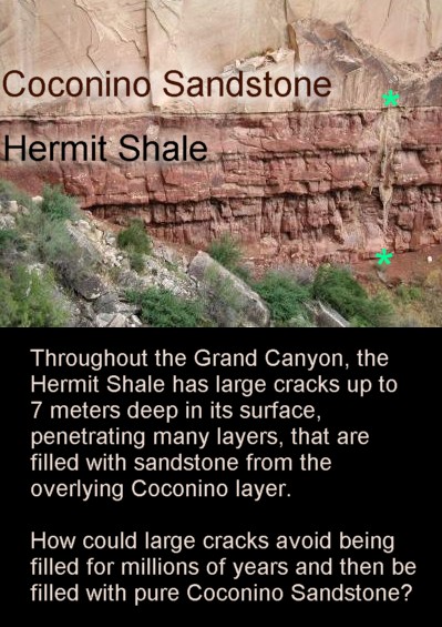 As an relevant aside, this is also the reason why large contraction or “desiccation” cracks in the underlying mudstone shales (like the Hermit Shale below the Coconino Sandstone) formed after the overlying layers were already formed. That is why these cracks are filled only with material from the overlying layer (pure Coconino Sandstone in the case of the Hermit Shale cracks). Consider also that there is no significant erosion between the Coconino Sandstone layer and either the layer above it (the Toroweap Formation) or the layer below it (the Hermit Formation). All of these layers formed like sheets of glass – one on top of the other. Isn’t it strange that significant portions of these layers have not been weathered away to be filled in by overlying layers in an uneven way? If the Hermit Formation took millions of years to form, which would surely turn the layers in this formation into solid rock in a small fraction of this time, how did such deep cracks form in solid rock in such a way that the surface was completely flat and yet the cracks themselves were filled with pure Coconino sandstone? One would think that if such formations and characteristics took very long periods of time to form that the boundary between the Hermit Formation and the Coconino sandstone would have been blurred by “bioturbation”, disturbed in an uneven way by erosion, and that the cracks found in the Hermit shale would have been filled with other contaminants besides pure Coconino sandstone. Of course, these findings are not strange if the layers were all formed rapidly and catastrophically by water deposition instead of over vast expanses of time. Interestingly, in 2010 Whitmore published a paper (Link) arguing that most of the cracks in the Hermit shale were not causes by desiccation, but by downward clastic dikes – which would require that the Coconino Sandstone not be cemented or consolidated when these clastic events occurred. This, of course, would much more easily explain the purity of the Coconino Sandstone that fills these cracks in the Hermit Shale – as well as numerous other features detailed in the paper (Whitmore, 2010).
Tapeats Sandstone:
In this line consider the distribution of the Tapeats Sandstone:
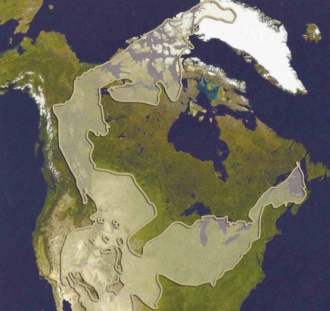
The Tapeats Sandstone corresponds to the base of what is known as the Sauk Megasequence, the lowest of six sediment megasequences, originally identified and described by Sloss (1963) in North America, that are separated from one another by global-scale erosional unconformities (Snelling 2009, 528-530, 740-741). Figure 11 [to the right here] is a simplified representation of how these six large packages of sediment are distributed in an east-west direction across the North American continent. What is striking is that separating each megasequence from the next is a craton-wide erosional unconformity. The six erosional unconformities essentially beveled the continental surface flat before the deposition of the next thick sequence of sedimentary layers. As just mentioned, the Tapeats Sandstone and its equivalents lie just above the first of these six erosional unconformities. It is also useful to note here that where Neoproterozoic Ediacaran sediments are present, this first erosional unconformity occurs just beneath these sediments. The basal formation of the next megasequence, known as the Tippecanoe Megasequence, is the widely distributed St. Peter Sandstone.
John Baumgardner, Ph.D. | Noah’s Flood: The Key to Correct Interpretation of Earth History | Sep 18, 2013 | Link
 So, this suggests that after the first massive tsunami(s) swept across the entire Earth after the Earth’s the crust of the entire Earth was broken up within a single day (Genesis 7:11). This generated a massive erosion event that planed off the surfaces of what are today’s continental land masses. After this initial massive erosion event, there were repeated waves of sediment deposition across the continental surfaces as the Flood proceeded during the initial and subsequent months comprised of many massive tsunamis and waves of sediment erosion and deposition.
At this point, then, we have several independent lines of evidence (paleocurrents, features of underwater deposition, and sediment transport) pointing toward the same conclusion – all consistent with a massive Flood (at least for the origin of the Navajo Sandstone and other Mesozoic sandstone layers as well). But, what about the Paleozoic Coconino Sandstone in particular?
Similar Features in the Coconino Sandstone?
As it turns out, many of the features that pointed toward and underwater origin for the Navajo Sandstone are also present within the Coconino Sandstone – plus some! Interestingly enough, the sand that forms the Coconino Sandstone (late Paleozoic) is also thought to have been derived from the Appalachian region and transported across the entire continent:
Our database for Mesozoic strata in the Four Corners region includes 2213 concordant or nearly concordant U-Pb ages of detrital zircons from 24 samples (Triassic to Cretaceous)… Eolian dune sands of Glen Canyon and San Rafael ergs were derived largely from pre-Atlantic rift highlands along the Appalachian belt, transported to deltas or floodplains in the northern Rocky Mountains region by a transcontinental paleoriver system ~2000 km long carrying Appalachian-derived sediment, and delivered southward to the Colorado Plateau ergs by the paleowinds recorded by dune crossbedding…
U-Pb ages for individual DZ [detrital zircons] grains in Mesozoic strata of the Four Corners region shed fresh light on provenance relations over both space and time… The ultimate bedrock sources for a high proportion of the DZ grains are located in the Appalachian and Ouachita regions of eastern and southern North America, with only 15% of the DZ grains derived from Cordilleran igneous assemblages of western North America. Without DZ analysis, the distal origin of such a large fraction of sedimentary detritus in Mesozoic strata of the Colorado Plateau would not be evident.
Dickinson and Gehrels, New Mexico Geological Society Guidebook, 61 U-Pb ages of Detrital Zircons in Mesozoic Strata, 135 st Field Conference, Four Corners Country, 2010, p. 135-146. (Link).
[Note: These same authors argued, in an earlier 2003 paper, that up to 34% of Coconino Sandstone zircon grains, which are late Paleozoic, are also of Appalachian origin (Table 4, Link]
It seems like sand transport across the entire continent is quite a “distal origin” indeed for nearly all the sand in the sandstone for the entire Mesozoic layers and even some of the Paleozoic layers in and around the Grand Canyon and widely surrounding regions. And rivers and wind transported it all over the course of millions of years? Let’s look at the evidence a bit more closely here…
Here are several of the most common arguments used in favor of a desert origin of the Coconino Sandstone compared with more recent discoveries:
Fossilized sand dunes are steep like those found in modern desert dunes:
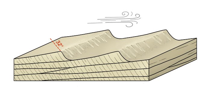
 In modern deserts, dry sand avalanches down the back sides of desert sand dunes at a steep angle of repose (about 32˚ – 34˚). As the windblown sand becomes too steeply piled, it avalanches again down the slope to make a distinctive tongue-like deposit. This process produces “cross-bedding”.
The reality here is that hundreds of measurements have been made by those like Whitmore et. al. (2015), as well as many other geologists which showed an average dip of only about 20˚, comparable to underwater sand dunes that commonly occur today on the continental shelves. The lack of angles in the 32˚ – 34˚ range speaks against an eolian origin for the Coconino Sandstone.
Some have argued that the weight of the overlying rock formations must have compacted the sandstone and thus lowered the steep angles below that expected for desert dunes. However, as explained above for the Navajo Sandstone, there is no microscopic evidence of such compaction nor is there reasonable experimental evidence for this degree of compaction.
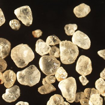
Sand grains are well-rounded like those of desert sand dunes:

Sahara Sand
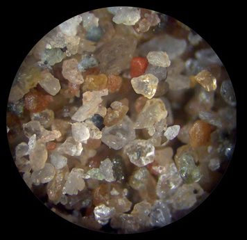
Beach Sand
Coconino Sand
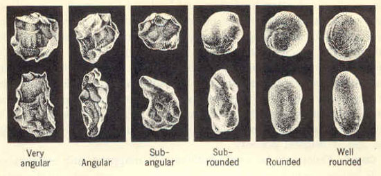 In modern deserts, sand grains (especially the larger ones) become well rounded as wind blows them about. Sharp angular corners get broken off during grain-to-grain collisions, and the grains become more spherical as well as more “rounded” in shape. In fact, laboratory experiments have shown that wind-born sand grains become more rounded in shape 100 to 1000 times faster compared to fluvial or water-driven abrasion rates (Kuenen, 1960). However, Whitmore et. al. (2015) found that the Coconino grains are not as well rounded as would be expected for desert sand, but maintain relatively angular shapes (with a high level of statistical significance compared to desert dune sand from regions like the Sahara Desert). The same is true for the Navajo Sandstone.
So, it appears as though the argument for desert-level well-rounded sand grains within the Coconino is based on the a priori assumption of a desert dune environment rather than on direct observation and careful examination of the Coconino Sandstone itself.
Of course, despite long assumptions to the contrary (held since the mid 1800s), the sand in desert sand dunes is not always well rounded – but is often angular. Studies done since the 1980s have shown that most quartz dune sand grains are not well rounded. Goudie and Watson (1981) examined fine and very fine sand grains in 108 dune sand samples from different parts of the world and found that well rounded grains are relatively rare (about 8% of the grains examined). In fact, there seems to be a systematic increase in angularity with decreasing grain size – which seems intuitive. And, since the Coconino sand is also a fine-grained sand, the relative lack of roundedness does not necessarily mean, by itself, that the Coconino Sandstone is of under water origin. What it does mean, however, is that the sand grains themselves do not favor desert conditions vs. underwater deposition. Also, assuming the existence of such desert conditions for very long periods of time (like millions of years) the lack of roundedness of these grains of sand would actually favor a much shorter-lived process or a much less abrasive process (like water deposition).
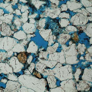
Sand grains are well-sorted as with desert sand dunes:
 The sand grains within a given desert dune are all very similar in size, or “well-sorted.” When the wind transports sand, it tends to carry and deposit only a select group of sand grains that have similar grain sizes (the size of which is dependent on wind speed). However, Whitmore et. al. (2015) found that that the Coconino’s sand grains are not as well-sorted as those in modern dune sands. In most cases, the Coconino can best be described as moderately to poorly sorted, based on over 100 samples studied under the microscope.
When most geologists look at the Coconino grains, they use a low-power hand lens as they walk along a hiking trail. Very few have actually collected samples for thin section analysis under the microscope. However, when this is done many smaller grains can be in seen between the larger grains of sand. This finding highlights the limited amount of sorting that is actually present within the Coconino Sandstone – as we would expect from underwater deposition rather than a desert environment.
A year earlier, Whitmore et. al. (2014) found that almost all of the thin sections studied in detail (>100x), showed thin and soft flakes of mica. Such mica flakes are common in water-deposited sandstones, but essentially absent in desert dunes because micas are easily abraded and destroyed by grain to grain collisions that happen when sand grains are carried across a sand dune by wind. However, this doesn’t happen to the same degree when sand dunes are transported and formed under water. Dolomite was also found at a number of locations, including dolomite ooids, which are small sand-sized pellets that typically form in shallow marine settings (One of the first reports of dolomite ooids in the Coconino Sandstone).
Sand grains are frosted, indicating a desert environment:
 In deserts, the wind picks up sand grains and forcefully throws them against each other. This causes small imperfections on the surfaces of the quartz sand grains and gives them a “frosted” appearance when viewed with magnification. The same thing happens to glass when sand is blown against it. This is known as mechanical frosting, since physical (or mechanical) forces produce it. However, laboratory experiments show that mechanical frosting happens more often to larger sand grains compared to smaller ones like those found in the Coconino. The reason for this is that smaller sand grains do not gain enough momentum to strike each other with sufficient force to produce the frosting effect. The sand grains of the Coconino are frosted, but their average size is so small and fine that a mechanical cause is unlikely to have been the cause of their frosted appearance.
So what caused the frosting? Studies by Whitmore et. al. (2015) carried out with the use of a scanning electron microscope showed that the culprit is probably chemical corrosion and not mechanical in nature. A study of the Navajo Sandstone found a similar result. This fact was known back in the early 1970s. For example, Stanley et al. (1971), when studying the Navajo Sandstone, pointed out that, “grain frosting is no longer considered a criterion of wind transport.” It was also known in the early 1960s that the chemical process of sand cementation in the forming of sandstone can also cause pitting and frosting (Kuenen, P.H. and Perdok, W.G., 1962). Clearly then, the frosting of sand grains is not good evidence for the desert origin of the Coconino Sandstone.
Fossil raindrops prove a subaerial eolian environment:
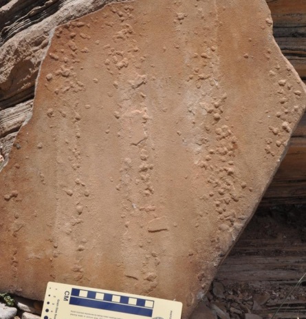 Rare impressions preserved within the Coconino Sandstone have long been interpreted as raindrops, despite a few unusual features. For example, these indentations are sometimes linear in nature, not entirely random as would be expected from raindrop impressions (Link). However, there are also examples of the more expected random-type raindrop impressions within the Coconino Sandstone. And, taken individually, many of the examples do indeed have the appearance of true raindrop impressions – even those found in linear array (Menendez, 2014). However, these raindrops appear to have been produced on very wet, rather than dry, sand – as in a situation where it has been raining for quite some time (or during a temporary regression of the Flood). Perhaps the linear arrangement of some of these raindrop
 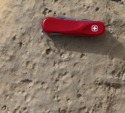 fossils is due to a slight wave in the sand where only part of the sand ripples extend above a thin film of water, allowing for the formation and/or preservation of more distinct raindrop impressions?
In any case, the presence of real raindrops, on rare occasions, within the Coconino Sandstone or other sandstone layers within the fossil record is consistent with a massive complex Flood of Noachian proportions that occasionally had periods of withdraw, for a time, from various locations – leaving periods of exposed ground that allowed for the preservation of occasional raindrops, trackways, or dinosaur nests.
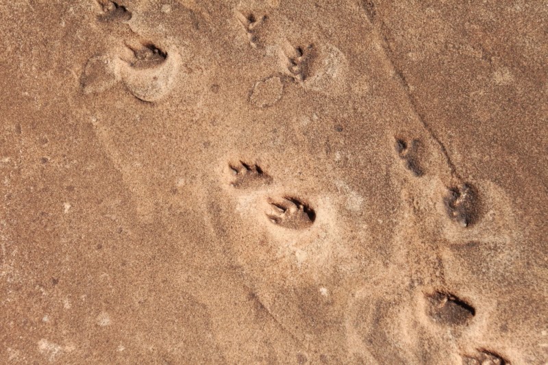
Vertebrate footprints support a desert environment rather than an underwater environment:
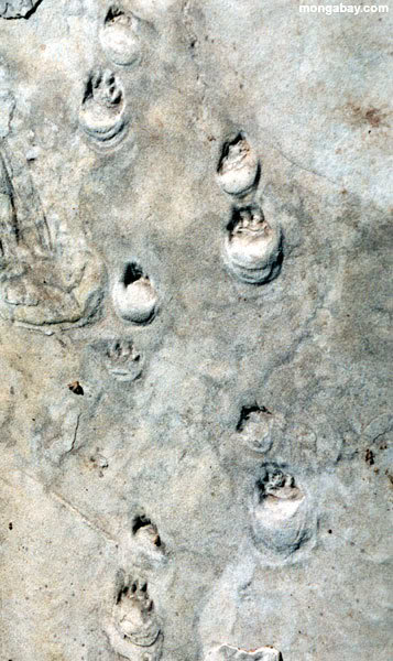 Now comes what is often used as a clenching argument by those who support a desert origin for the Coconino Sandstone – the vertebrate footprints. All throughout the Coconino Sandstone are preserved footprints of vertebrates such lizards or other similar reptilian or amphibian creatures, as well as less common worm, spider, and arthropod trails – and even a few rare burrows. The vertebrate tracks have been referred to as “amphibians and/or reptiles,” but from the structure of the tracks the majority of them are most easily interpreted as amphibians – however strange it might be to have a majority population of amphibians living happily in a desert environment. This is generally explained by suggesting that the desert sands bordered the ocean or a seaside area. The footprints are located on the preserved surfaces of the dunes and are believed to have been covered by the shifting dune sand and thus preserved for all time. No other fossils have been found in the Coconino Sandstone to include evidence of any plant life (which seems strange since animals and plants usually go together – even in a seaside desert). But, given all of these facts, it seems obvious to most that the Coconino Sandstone is in fact a preservation of a very large and ancient desert. However, there are several fundamental problems with this conclusion with respect to these trackways in particular…
Uphill Only (well… almost always):
 First off, consider that the animals that created trackways within the Coconino, Navajo and other sandstone layers in this region all had a very strong tendency to walk uphill. This is true for all the various animal types that created trackways within these sand (i.e., lizards, salamanders, arthropods, synapsids, etc.). This sort of almost exclusive uphill walking isn’t seen anywhere in any modern desert. According to Lockley (2016), to this day, “No one really knows why this is.” Evidently the lizards/amphibians, arthropods, and other smaller creatures living in ancient deserts did not like going downhill much at all. Also, trackways often start and stop suddenly without evidence of sand-shift or disturbance – like the creature suddenly vanished into thin air (Link).
Notice also the title of McKee’s 1944 paper, “Tracks that go uphill” (McKee, E.D., Tracks that go uphill. Plateau, 1944,16(4):61-73). McKee attempted to explain the relative absence of downhill trackways by suggesting that the animals tended to “slide” downhill, thus obliterating their own tracks in the sliding sand. One might wonder why the animals would slide downhill when they were doing do fine going uphill without the sliding problem. Those who have ever visited areas with desert sand dunes will find that trackways on such sand dunes go every which way. Also, one would expect that wetted sand would be much more cohesive than dry sand and preserve tracks just as crisply no matter which direction the creatures were heading.
And, just in case there was any doubt, Leonard Brand actually went to the trouble of inducing his experimental animals to walk both downhill as well as uphill. On underwater sand, wet sand, and damp sand, almost all downhill trails produced easily recognizable trackways. On dry sand, the trackways of salamanders were less well defined, but still relatively well preserved, while that of lizards were still quite distinct (both walking or running slowly). Only when running very fast did their tracks become unrecognizable (Leonard Brand, 1978;1991).
Thus, the almost complete absence of downhill tracks in the Coconino, Navajo and other sandstone layers in this region seems to remain a mystery if they are truly desert formations. It almost seems as though the creatures were trying to escape something, like rise water levels, and that is why they were all generally going uphill…
Very crisp well-defined prints:
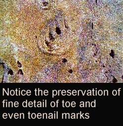 The footprints themselves are very crisp and well defined. Such well-defined footprints cannot be made in dry desert sand or even damp sand, but only on underwater or deeply saturated and very wet sand (according to experiments by Leonard Brand, 1978; 1991). Brand document that all five species in his study (including lizards and salamanders) walked on the bottom sands underwater more than they swam from place to place through the water as long as they had a sandbar or some place in the testing tank where they could rest. Brand noted that this behavior is also observed in the field. When walking along the sand underwater all five species selected by Brand produced distinct footprints with toe marks and occasional sole impressions all along their trackways. Brand concluded that, “The underwater tracks were most similar to the fossil tracks. Underwater trackways had toe marks as often as the fossil tracks, and they were uniform in appearance the full length of the sand slope, as the fossil tracks are. Also, the proportions of the fossil tracks were most similar to that of the underwater tracks.”
Arguments against Brand and Uphill Trackways:
Of course, there are those who have argued strongly against Brand’s suggestions and conclusions. A fairly extensive summary of these arguments were recently put together by Robert T. Johnston (Uphill-only Dinosaur Tracks? A Talking Rocks 2017 Participant Seeks Answers, November, 2017).
.
My own response to Johnston’s article can be found here: Link
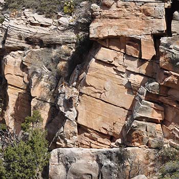
Recumbent parabolic folds:
It is also interesting to note a fairly recent observation in the Coconino Sandstone of extensive and fairly common folds called “recumbent parabolic folds” (which are also quite common in the Navajo Sandstone as well – McKee, 1979, p. 213). Here is the abstract published by Whitmore et al., 2015 (Link):
We report sedimentary structures that in all ways resemble parabolic recumbent folds (PRFs) in the cross-bedded portions of the Schnebly Hill Formation, the Coconino Sandstone and the Toroweap Formation (Arizona, USA). Field evidence suggests they are penecontemporaneous and intraformational. Intraformational refers to deformation that occurs between undeformed beds. Recumbent cross-bed sets occur over a wide area (>375 km2 [144 mi2]) at many different locations and horizons in the Sedona area, especially within the Coconino Sandstone. Deformation resulting from slumping dunes (dry or damp) is ruled out because of the nature of
the deformation along cross-bed dip, the size and length of the deformation along horizontal beddingplanes (sometimes up to 170 m [557 ft] along dip) and the lack of small faults usually concurrent with such slumping known from modern dunes. Neither do the folds resemble deformation that has been caused by post-depositional groundwater movement or seismic activity which often produces convolute bedding. We do report some seismic features in the Schnebly Hill Formation, but these features have distinct characteristics that distinguish them from PRFs.
Although the exact mechanism of PRF formation is still debated, it is generally agreed that strong water currents combined with liquefaction play major roles in overturning the top of a cross-bed set during the deposition of the cross-bed. Rare planar-beds, directly associated with the PRFs in the Coconino, suggest that the needed liquefaction may have occurred from changes in flow regime. Some workers have already suggested that parts of the Schnebly Hill and Coconino were deposited by marine sand waves on a shallow continental shelf; a hypothesis that is considerably strengthened in light of these new data along with additional petrographic data that we have collected.
Conclusion:
It seems, then, that there are multiple lines of evidence pointing toward an underwater formation of the sand dunes within the Coconino Sandstone (an the Navajo Sandstone as well). Those features that originally seemed to favor a desert environment no longer seem to point in this direction after additional information and laboratory experiments have come to light. Yet again, the claims of the authors of the Bible regarding a worldwide Noachian Flood seem to be more in line with the empirical evidence despite the ardent beliefs and claims of most modern geologists, skeptics and critics.
Here is a summary of the main points presented above for both the Coconino and Navajo Sandstone formations (Link):
- Examination of the animal track ways in the beds and comparison with modern experiments of track ways made under various sand conditions show that they were made on very wet heavily saturated sand. (Brand)
- The observation that the trackways almost always tend to go uphill, starting and stopping suddenly without evidence of sand movement, is quite problematic for the hypothesis of a desert environment.
- Dinosaurs buried by sudden slumps or collapses of large quantities of sand, perhaps while still alive, requires very wet and perhaps even underwater conditions.
- The grain size plot shows the signature of sand grains moved by water rather than wind. (Visher)
- The sand grains are not well sorted, favoring an under water origin (Whitmore)
- The presence of mica flakes within the sandstone favors an under water origin (Whitmore)
- The presence of dolomite, also found at a number of locations (including dolomite ooids which are small sand-sized pellets that typically form in shallow marine settings) favors an under water origin. (Whitmore)
- Parabolic recumbent folds require underwater conditions. (Whitmore)
- The transport of the sand that makes up the Navajo and much of the Coconino Sandstone across the entire continent from the Appalachians favors an under water origin.
- The very widespread distribution of megasequences (like the Tapeats Sandstone and other similar sequences) cannot be explained as sediments distributed over long periods of time by river transport. (Sloss)
- Paleocurrents generally moving the same direction, from east to west, during the Paleozoic favor an under water origin. (Chadwick)
- The paucity of examples of the characteristic large dune signature angle of repose (30˚-34˚) casts grave doubt on the eolian origin theory. (Austin)
- The presence of ‘current lination’ testifies to the water deposited nature of the sandstone. (Visher)
- Pelletal glauconite within sandstones is also consistent with water transport (Visher)
- Pitting and ‘frosting’ marks have been shown to be non-diagnostic. (Kuenen and Perdock)
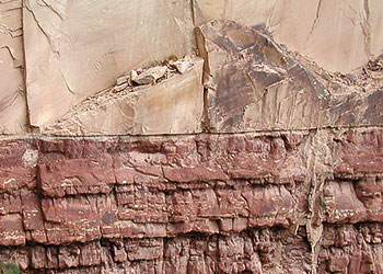 Clearly the beds were planed off below before deposition, and planed off above after deposition. Only water accounts for this. A fast current planes. A slower current deposits, and then a faster current planes before the next deposit. Was the sand a dry crossbeded desert before being planed off above? This would be impossible since any water planing it off would have sunk into the desert and eroded it destroying the cross bedding or redepositing it as water laid crossbeds erasing all the evidence of the mythical desert.
- The solid nature of the sandstone testifies to its being a water mix. Otherwise, the cementing agents for the sandstone could not be chemically active. One cannot plead dew or light rain for this because this does not explain the relatively flat bottom or top of the formation. Or, even if such dew or light rain is invoked, the sandstone would have turned solid much too quickly for other features, such as clastic dikes, to be realized.
- Large clastic pipes and dikes more consistent with relatively rapid deposition of most of the layers of the geologic column, to include the Coconino and Navajo Sandstone layers, before cementation and consolidation could occur.
- The planer crossbedding observed can be formed by sand waves or tubidity currents.
- Large numbers of fossilized conifer trees oriented with respect to each other (Parrish), much more consistent with flood deposition than with a desert environment.
- The one feature that remains largely unexplained from the Flood perspective is wind-ripple laminae. This particular feature has some correlation to certain kinds of underwater ripples and additional correlations may be realized with more detailed investigations of underwater dune formation. Or, given that they are fairly rare within the Coconino and Navajo Sandstone, may represent fairly brief periods of subaerial exposure during Flood regressions following tsunamis or tidal actions – which would also explain the rare raindrops as well as the occasional uphill trackways preserved on very wet sand during a world-wide Flood. The same would also appear to be true for the numerous dinosaur nests created by very stressed dinosaurs worldwide.
 0
0 0
0


 0
0
 0
0 0
0 0
0 0
0


This is very interesting. I am working on a Flood project myself. Please feel free to reach out to me!